Importing stop-off point lists and address lists
Some of the data created in PTV Map&Guide desktop can be imported into PTV Map&Guide internet.
Import stop-off point lists
Stop-off point lists are saved in PTV Map&Guide desktop as bcr files in the directory ..\ProgramData\PTV-AG\PTV Map&Guide desktop\<version number>\data\prog.mov.
Note: If you import a bcr file into PTV Map&Guide internet, only the stop-off points are imported. The settings for route planning, such as the vehicle used or the assigned costs, cannot be imported.
There are two methods of importing the stop-off point lists:
-
Via the
 Import function above the stop-off point list.
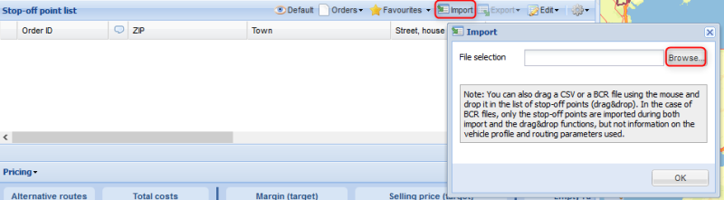
-
By dragging and dropping the files into the stop-off point list.
Tip
If you have saved several routes in PTV Map&Guide desktop, manual adoption using the import function or drag-and-drop may take some time. To make the switch easier, we have developed a tool which automates this process.Our support service will be happy to provide you with the "BCRdesk2inter“ import tool as required.
Importing address lists
Address lists that you have created in the Data Manager can be imported as csv files in PTV Map&Guide internet.
Export from PTV Map&Guide desktop
-
Open the Data manager use case.
-
Choose the desired address list via
 Open table.
 -
Start the export assistant via
 Export data.
 -
On the page Step 2, ensure that the option First two fields contain coordinates is selected.
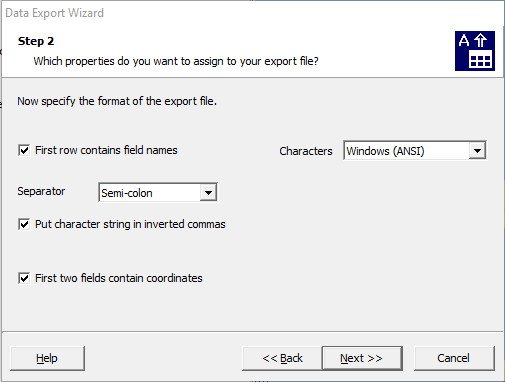
Note: Exporting coordinates is especially important if you have manually moved addresses on the map in PTV Map&Guide desktop. This ensures that the addresses on the PTV Map&Guide internet map are displayed in the right place.
-
Follow the instructions in the wizard and export the data as a csv file.
Import in PTV Map&Guide internet
-
Open the Data Manager use case.
-
Click on
 New Database on the toolbar above the table.
 -
On the General tab of the import assistant, select the previously exported csv file.
A preview of the addresses is displayed in the lower area of the window.
-
If necessary, adjust the import file settings automatically selected by PTV Map&Guide internet.
-
Click on Next.
-
In the tab Table structure, check whether the field types are correctly assigned and confirm this with Continue.
-
In the tab Graphic representation, select the symbol you want to use to mark the addresses on the map and confirm with Next.
-
In the tab Geographical information, select the option Geocoding using coordinates or location information.
-
Start the geocoding process.
The data are geocoded. A statistic is displayed when geocoding is complete.